Roads, Emergency, Bushfire, Flood & Safety
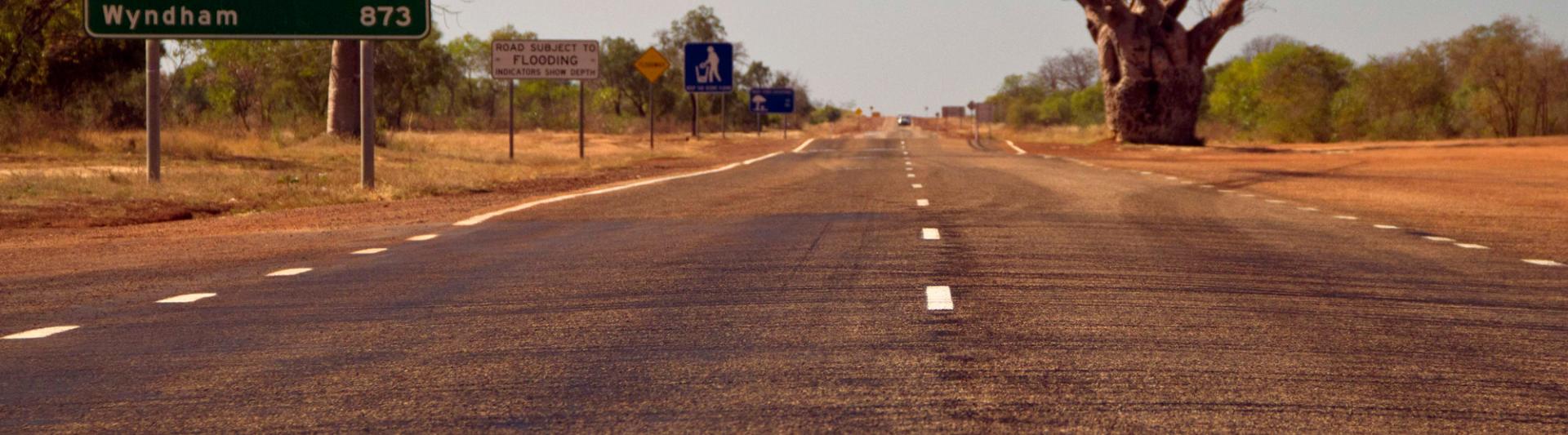
The Kimberley region of Western Australia experiences harsh weather extremes between the wet and dry seasons. Flooding and extreme weather can cause delays to occur. Be sure to carry (at ALL times) a supply of fresh water and suitable food, as well as extra tyres. During the wet season, road conditions within Broome and the Kimberley region can change dramatically (over a short period of time) making some roads inaccessible at short notice. Floods occur quickly with heavy rainfall along the roads, and can wash out floodways, making them very dangerous for both experienced and inexperienced drivers. Always follow the safety advice and if a road is closed, or appear to be dangerous, don't risk it! High clearance 4WD’s recommended on all unsealed roads.
Extreme caution should be used at floodways and creek crossings. It is not recommended to tow trailers and caravans on these roads. Do not drive into water of unknown depth or velocity. Check water depths before entering and do not enter floodways if the depth is unknown. Local knowledge is required and you must respect the land, culture and privacy of the local people. Stay informed about our remote Aboriginal communities and the access conditions for these areas. Some areas may require permits. Respect the signage and road advice as you travel.
Be sure of your routes and itinerary before you leave, and always check the weather forecasts. Drive with caution particularly in the hours between dusk and dawn. Drivers should travel in accordance with road conditions at all times. Refer to the local tide chart before venturing north. When departing Broome, you should be self-sufficient with the essentials: food, water, supplies, spares, emergency aids and fuel.
During a power outage, your home phone, computer or other electronic devices connected to the NBN will not work. Include a battery powered radio in your emergency kit.
Main Roads Travel Map
The Main Roads Travel Map is the most up to date resource for checking road closures and roadworks in Western Australia. Remember to plan your journey. Please be advised of the Main Roads Travel map Disclaimer before using the online travel map. You can also call Main Roads WA 138 138
ACCESSING CLOSED ROADS AND / OR INTERFERING WITH ROAD CLOSED SIGNS IS AN OFFENCE. PENALTIES OF UP TO $10,000 APPLY.
Kimberley Traffic Broadcast
Friday, 3 July 2026 10:17 AM
■ CRASH CLEARED. Great Northern Highway At 2 Mile Creek
All lanes clear. All vehicles.
■ DEBRIS CLEARED. Great Northern Highway Near Fossil Downs Road, St George Ranges
All lanes clear. All vehicles.
■ ROAD SURFACE DAMAGE. Great Northern Highway At Guda Guda Community
Reduced to single lane traffic only. Temporary traffic signals in place. Speed reductions in place. Exercise extreme caution. All vehicles.
Looking for updates on Broome and Kimberley road conditions?
SHIRE OF BROOME
Click here for the Shire of Broome conditions - including local unsealed roads
Note: Broome-Cape Leveque Road is now managed by Main Roads WA, so check the Main Roads Travel Map regarding this road. Please be advised of the Main Roads Travel map Disclaimer before using the online travel map.
--
SHIRE OF WYNDHAM / EAST KIMBERLEY
The Shire of Wyndham / East Kimberley Road Report Map provides an up to date listing of road conditions. It is advised road users check for updates prior to travel. Road conditions can vary rapidly and a 4WD is recommended on all gravel roads.
3rd July 2026 update:
The Shire would like to advise of the following road updates:
✅OPEN TO ALL TRAFFIC
Kalumburu Road from the Gibb River Road to the Port Warrender Road turnoff
✅OPEN WITH CAUTION
Kalumburu Road from the Port Warrender Road turnoff to Kalumburu, based off the below conditions:
- Open to high clearance 4wd vehicles to 5t.
- Use caution in areas where water is over the road.
- Use extreme caution for floodways and river crossings
✅REMAINS OPEN WITH CAUTION
Port Warrender Road from Mitchell Plateau turnoff to the Mitchell Plateau Airstrip based off the below conditions:
- Open to high clearance 4wd vehicles to 25t.
- Use caution in areas where water is over the road.
- Use extreme caution for floodways and river crossings
⛽CAUTION: Fuel is limited north of Drysdale River Station. Please plan ahead, double-check availability, and carry adequate provisions before setting off.
📞 For more information on the Mitchell Falls campground, please contact DBCA: 08 91684200
--
SHIRE OF DERBY / WEST KIMBERLEY
The Shire of Derby / West Kimberley also provides a road condition report. Please be advised that this advice is only updated when conditions have changed.
> Shire of Derby/West Kimberley Road Condition Report - 15June 2026 - 0900
--
SHIRE OF HALLS CREEK
Road conditions website updates are usually posted here or on their facebook page.
> Wednesday 27 May 2026 – 10.00AM
- TANAMI ROAD – NT BORDER. OPEN TO ALL VEHICLES
- DUNCAN ROAD – NT BORDER. OPEN TO ALL VEHICLES
--
Always drive to road conditions. When travelling on Rural Roads in the Wet season, expect water across floodways, localised scouring, sandbars and washouts. We advise that extreme caution is taken. Restricted Road use is intended to prevent damage to roads and to ensure the safety of our travelers.
National Parks Updates
Check the National Park Alerts at https://alerts.dbca.wa.gov.au for the latest National Park information. Please do not attempt to travel on closed roads or access closed parks for your safety.
Western Australia is the largest state in the country and presents unique challenges for both local and visiting drivers.
Read some more tips for regional driving.
---
Continue reading below for more helpful links and resources.
Weather & Emergency Information
For up to date weather information go to the Bureau of Meteorology website
Visit BOM websiteKeep up to date on all alerts and warnings to go emergency.wa.gov.au
Go there nowFor recorded emergency information call 13 DFES (13 3337).
Click for more informationFor State Emergency Service emergency assistance during a storm, cyclone, earthquake, flood or tsunami call: 132 500
Find out about SES servicesRoad Conditions & Updates
Road Condition alerts, incidents and closures for most roads within Western Australia.
Read the Shire of Broome updates regarding road conditions. For unsealed road conditions and closures visit this page.
Go to Shire of BroomeRoad Reports for the Tanami Road, Duncan Highway and roads within the Shire of Halls Creek
View Shire of Halls Creek websiteRoad Reports for the Gibb River and Kalumburu Road and roads within the Shire of Derby / West Kimberley
View the latest road condition reports for the Shire of Wyndham / East Kimberley (including Kununurra, Ivanhoe Crossing and more)
See moreView the latest road condition reports for the Northern Territory
Download a copy of the G.O.A.T Gibb River Road guide
See moreMain Roads have also prepared information about driving the Gibb River Road and other roads in the Kimberley.

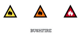
Introducing the Australian Warning System
The Australian Warning System is not active. Learn more below.The Australian Warning System is an easy-to-understand warning system that will help you stay safe during a bushfire no matter where in Australia you are. Knowing the warning levels, colours and icons will help you make important decisions to help you stay safe. The warning level icons and colours change to reflect the increasing risk to life or property, and the action you need to keep yourself and your loved ones safe.
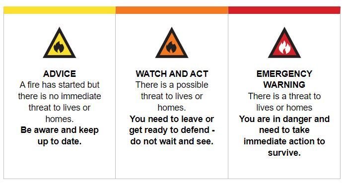
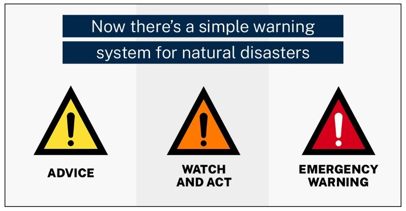
What are the warning levels?
There are three warning levels:
Advice (Yellow):
An incident has started. There is no immediate danger. Stay up to date in case the situation changes.
Watch and Act (Orange):
There is a heightened level of threat. Conditions are changing and you need to start taking action now to protect you and your family.
Emergency Warning (Red):
An Emergency Warning is the highest level of warning. You may be in danger and need to take action immediately. Any delay now puts your life at risk.
Watch > a video below explaining Australian Warning System
Travelling during Bushfire Season
If you plan to travel in bushfire season it’s essential you know what to do if you encounter a bushfire. Every year, people are killed or seriously injured by bushfires. If you’re travelling or staying near bushland, fire is a real risk for you. Follow these DFES tips to stay safe when travelling this bushfire season.
WHAT TO PACK IN YOUR BUSHFIRE EMERGENCY KIT
Before leaving on a road trip, it is essential to have a potentially life-saving emergency kit packed. Your kit should include essential items such as:
- AM/FM portable radio
- Spare batteries
- First aid kit
- Woollen blankets
- Drinking water
- Sturdy shoes
- Full-coverage cotton or woollen clothing
- Detailed printed map of the area where you’ll be travelling
TOTAL FIRE BAN
A Total Fire Ban (TFB) is issued for days when fires will be very difficult to control and are most likely to threaten lives and property. On a TFB day, all open-air fire activity is prohibited, including campfires, cookers and ovens that use solid fuel like wood or charcoal. Restricted and prohibited burning times are put in place during periods of high bushfire threat. Restriction times and restricted activities can differ between local governments, so it’s essential to check the local rules and current information of each place you plan to visit.
You can find out if a TFB has been declared in your area here, or by calling the TFB information line on 1800 709 355.
Watch > Total Fire Ban Video (AUSLAN) here
TRAVELLING WITH A CARAVAN
Make sure your caravan is as safe as possible by:
- Making sure your caravan has a smoke alarm, fire extinguisher and fire blanket.
- Securing your electrical and gas equipment and making sure it is appropriately fitted, in good working order, and turned off while travelling.
STAY UP TO DATE
When you are travelling, the best way to get bushfire information is via ABC local radio. In a major bushfire, ABC local radio will communicate emergency broadcast across all radio programs approximately every 15 minutes. You can find the frequency for specific areas here or by calling 1300 13 9994.
Watch > Stay Informed Video (AUSLAN) here
FIRE DANGER
Fire can come from any direction and paths can quickly become blocked. You should always be aware of your surroundings and look for signs of a bushfire, such as seeing or smelling smoke. When the fire danger rating is high, have a back-up destination. A city or town may be safer than a bushland area. If you plan to visit a bushfire risk area, be prepared to change your travel plans at short notice should a fire start. If you are staying overnight, make a fire plan that includes any existing bushfire safety plans for the area where you are staying. This plan should include more than one route to leave the area.
The radiant heat from a fire can kill from two football fields away. Plan to Be Safe and Leave Early.
Download > Bushfire Warning System Fact Sheet
Watch > Changes to the WA Bushfire Warning System video
WHEN IS BUSHFIRE SEASON IN WESTERN AUSTRALIA?
WHAT TO DO WHEN YOU ENCOUNTER A BUSHFIRE WHILE DRIVING
Bushfires can affect roads and highways, leading to reduced visibility and even road closures. Before you head out, always check road conditions first by contacting Main Roads WA on 138 138 or using this Travel Map to find current alerts, road works or traffic issues (Please be advised of the Main Roads Travel map Disclaimer before using the online travel map.).
If you see signs of a bushfire in the distance, like smoke or flames, carefully pull over to the side of the road to assess the situation and call triple zero. If it is safe to do so, turn around and leave the area immediately.
If you become trapped by a fire:
- Find an area off the roadway with little or no vegetation where you can park your car. Don’t park too close to other cars.
- Face your car towards the oncoming fire.
- Stay in your car. The engine may be left running so the headlights can operate and not flatten the battery.
- Turn headlights and hazard warning lights on.
- Close all doors and windows, shut air vents and turn off air conditioning.
- Get down below window level and cover your body with any woollen or cotton blankets or clothes.
- As the fire front approaches, the intensity of the heat will increase along with of smoke and embers.
- Smoke gradually gets inside the car and fumes will be released from the interior of the car. Stay close to the floor to minimise inhalation.
- Stay in the car until the fire front has passed and the temperature has dropped outside.
- Once the fire front has passed and the temperature has dropped, cautiously exit the vehicle.
- Move to a safe area e.g. an area that has already burnt.
- Stay covered in woollen blankets and await assistance.
STAYING OVERNIGHT
Whenever you are staying in a bushfire prone area overnight, be sure to:
- Find out the bushfire safety plans in place in the area.
- Find out where you can shelter safely nearby, in case you need to leave.
- Ask for information on alternative routes to leave the area.
- Always take advice from emergency services personnel if a bushfire occurs.
IMPORTANT NUMBERS
Save these important numbers into your mobile phone and write them down:
- DFES information line: 13 33 37
- National Relay Service for hearing impaired: 1800 555 630
- Reporting fires or emergency situations: 000
During an emergency, stay up to date by:
- Visiting Emergency WA
- Following DFES on Twitter or Facebook
- Listening to local ABC radio (Kimberley)
DOWNLOAD THE FOLLOWING DFES GUIDES:
- Travelling During a Bushfire
- Bushfire Warning System
- How Do I Keep Informed?
- Be Safe and Leave Early Plan
- Bushfire Preparedness Toolkit
- Safer Places in a Bushfire
- Sheltering in Your Home
- Bushfire Risks and Dangers
Bushfire warnings in WA
In Australia, we use the Australian Warning System (AWS). If you are not familiar with the differences between Advice, Watch and Act, Emergency Warning and All Clear, please learn them so you can follow advice given. If you live in a bushfire risk area you need to understand the Fire Danger Ratings and warning systems, stay informed, monitor local conditions and make your own decisions. The alerts provide information on the severity of bushfires once it has started. The alert level reflects the risk to life and property.
Make your bushfire plan today at www.mybushfireplan.wa.gov.au or on the app.
Download the app from Google Play or App Store
Watch > Video - My Bushfire Plan
Planned, registered or prescribed Burns
Department of Fire and Emergency Services WA advise that prescribed burns can occur in collaboration with local Aboriginal Ranger groups. Registered burns will appear at https://www.emergency.wa.gov.au/. If you see a fire and are not sure it is a prescribed burn, call 000 to report it.
Tropical cyclone season in the North West
November to April is tropical cyclone season in our North West.DFES advise us to be the calm before the storm when it comes to cyclones in the Kimberley. Tropical cyclones can impact the north west coast from November to April. Other areas like the Midwest-Gascoyne and Goldfields-Midlands often experience flooding as a cyclone moves south. Cyclones can be severe and cross the WA coast every year with destructive winds, torrential rainfall, flooding, dangerous storm surge and heavy swells. Your safety is your responsibility. Be the calm before the storm and follow the advice below to get prepared, stay informed and keep safe during the cyclone season.
The coastline between Broome and Exmouth is the most cyclone-prone region in Australia. Cyclones don’t only impact coastal towns - they can also bring dangerous wind and flooding to inland communities. DFES and the Bureau of Meteorology (BoM) work together to inform the community when there is a cyclone risk. Once BoM issue a Tropical Cyclone Watch or Warning, DFES will provide warnings and advice on Emergency WA.
For more information and the latest updates visit www.emergency.wa.gov.au
For current Bureau of Meteorology Watch and Warnings visit www.bom.gov.au/cyclone.
Cyclone Resources from DFES
- Travelling During the Wet Season Guide
- Australian Warning System Flyer
- Cyclone Emergency Kit Information
- Tropical Cyclone Preparedness Guide
- When you should call the SES
- What is a storm surge?
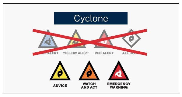
July 2024 - Note: Changes to the Australian Warnings DFES issue for cyclones.
DFES will no longer be using the old Blue Alert, Yellow Alert, Red Alert and All Clear warning system. Instead warnings will either be Advice, Watch and Act or Emergency Warning depending on the risk to the community and the forecast time to impact. The main benefit of using the AWS framework for cyclone warnings is that we can now de-escalate, or downgrade warning levels after the cyclone has passed. Previously under the old system, warnings would jump straight from a Red Alert to an All Clear once the cyclone had passed. Now we will downgrade from an Emergency Warning to either a Watch and Act or an Advice depending on the cyclone's impact and what risks remain for the community.
View the Australian Warning System Flyer (DFES, pdf)
Watch a short video about the new Australian Warning System
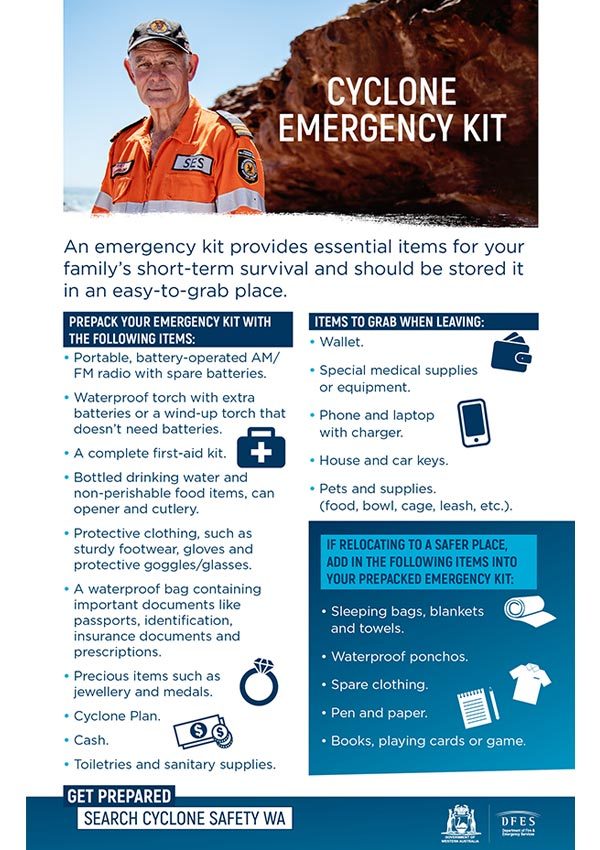
Preparing a Cyclone Emergency Kit
Please watch the two short videos below.
Be Flood Smart
Australia has a history of floods, causing devastating human and economic impact. Floods are a natural process influenced largely by the weather and driven by the amount of rainfall and length of time it falls. After heavy rainfall, rivers, creeks and catchments may overflow this type of flooding is most common in Australia and is known as riverine flooding.
Floods can be devastating and can happen anywhere, anytime. Make sure you understand the risks of flooding and take steps to avoid injury or death.
Western Australia (WA) is the largest state in Australia with a vast range of climatic conditions and seasonal changes that influence and increase the potential for flooding.
If you live or travel in a flood prone region, then you need to prepare for the possibility of a flood endangering you, your family and impacting your property, even isolating you from the community and essential services.
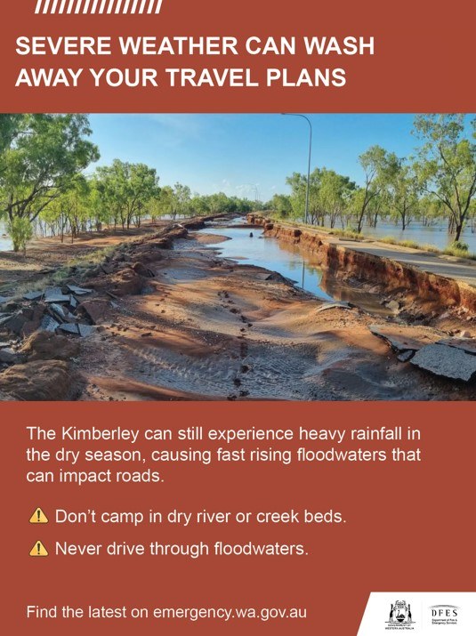
Floodwaters can rise fast in the Kimberley
WHAT TO DO
- Prepare to relocate equipment and livestock early so they are not caught in floodwaters.
- Prepare an emergency kit including enough canned food and water to last for four days, as well as clothing, important documents, and medication.
- Fill your vehicle's fuel tank.
- Watch for changes in water levels so you are ready if you need to evacuate
- Never walk, swim, or play in floodwaters, as they are dangerous.
- Stay out of rivers, this includes no swimming or kayaking.
- Do not park or camp adjacent to rivers. Rivers and creek beds can rise quickly, putting campers at risk.
IF DRIVING:
- Be careful at crossings and floodways as river levels may rise rapidly.
- Obey road closure signs and do not drive into water of unknown depth and current.
- Take care on gravel and unsealed roads as they may be slippery and muddy, and you could get bogged.
- Carry extra food and water when travelling in case of long delays at crossings
IMPORTANT NUMBERS
- For SES assistance call 132 500.
- In a life threatening situation call 000.
- For the latest flood information call 1300 659 210 or visit the Bureau of Meteorology
KEEP UP TO DATE
Visit Emergency WA, call 13 DFES (13 3337), follow DFES on Twitter, Facebook, listen to ABC Local Radio, or news bulletins.
During a power outage, your home phone, computer or other electronic devices connected to the National Broadband Network will not work. Include a battery powered radio in your emergency kit. Don't rely on having internet access when travelling in the Kimberley.
Dangers of flooding - from DFES
Floodwaters are very dangerous. Water can be deep, fast flowing with strong currents and have sharp objects that can injure or trap you. Floodwaters can also contain toxic waste, chemicals and dangerous animals. Not only can floodwater endanger human life, it can also damage infrastructure such as buildings, bridges and roads.
Most flood related deaths have occurred when people have attempted to drive through, walk, swim or play in floodwater. People have been seriously injured from debris or have drowned after being trapped in their vehicle or washed away in fast flowing water. People who have taken action to be prepared for a flood before it happens are more likely to keep themselves, their families, their pets and their properties safe during a flood. Find out how to prepare for a flood.
Never try to drive or walk through a flood.
If you choose to drive through floodwater, you are choosing to risk your life and those of your passengers. Find out more about travelling during a flood.
DFES and the Bureau of Meteorology (BoM) work together to inform the community when there is a flood risk. Once BoM issue a Flood Watch or Warning, DFES will provide alerts and warnings on Emergency WA. There are five warning levels that align with the expected timing of floods.
Floodwaters are very dangerous and can threaten your home and community. While floodwater can sometimes take time to reach you, if flash flooding occurs then it happens very quickly and can take you by surprise. You should expect floodwater to be deep, have strong currents and sharp objects that can injure or trap you. Floodwaters can also contain toxic waste, chemicals and dangerous animals. Read more about what to do during a flood event.
What are the warning levels?
There are three warning levels:
Advice (Yellow):
An incident has started. There is no immediate danger. Stay up to date in case the situation changes.
Watch and Act (Orange):
There is a heightened level of threat. Conditions are changing and you need to start taking action now to protect you and your family.
Emergency Warning (Red):
An Emergency Warning is the highest level of warning. You may be in danger and need to take action immediately. Any delay now puts your life at risk.
Watch this video about flood safety from DFES.
Read >PDF transcript
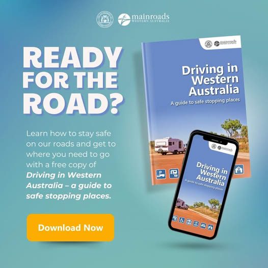
Driving in Western Australia
A guide to driving in Western AustraliaPrepare for your next road trip downloading a copy of Main Roads Driving in Western Australia Guide
- Safe stopping places
- EV charging locations
- Parking bays and rest areas
- What to expect on the road in WA
Emergency+ App
Download the Emergency+ smartphone app, as a useful method to identify and share your location, especially in emergency and breakdown situations. The Emergency+ app is a free app developed by Australia’s emergency services and their Government and industry partners. The app uses GPS functionality built into smart phones to help a Triple Zero (000) caller provide critical location details required to mobilise emergency services
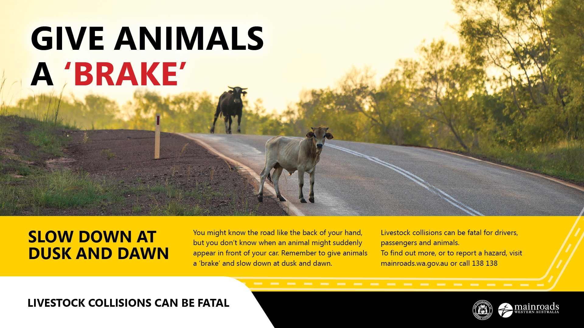
Straying wildlife on roads
You might know the road like the back of your hand, but you don’t know when an animal might suddenly appear in front of your car.If you’re travelling on regional roads, remember to slow down at dusk and dawn and keep an eye out for straying animals. Live stock collisions can be fatal, so remember to give animals a ‘brake’ if you see them on or near the road when you’re driving. Stay alert and watch out for animals when driving, especially when they are most active during dusk and dawn.
Keeping family pets safe when travelling
Holiday makers who take their dogs when travelling around regional Western Australia are being reminded to keep them safe from 1080 baits.1080 baits are used extensively by farmers and pastoralists throughout the State on both private and government lands to control feral pests, including wild dogs, foxes, pigs and rabbits, which threaten livestock and biodiversity. Tourists travelling with pet dogs are urged to consider putting them on a lead, muzzling when off lead, or avoid bringing them on holiday to prevent them being poisoned.
Department of Primary Industries and Regional Development (DPIRD) regional biosecurity coordinator Lindsay Strange said while the use of 1080 baits was strictly regulated, pet owners needed to take responsibility for the safety of their animals. DPIRD will distribute a ‘1080 baiting: a must for pest control but a risk to domestic pets’ flyer to tourist hotspots as a further reminder for dog owners to keep their pets close. If poisoning is suspected, seek immediate medical attention or veterinary assistance or contact the Poisons Information Centre on 13 11 26.
Read full article | Download as a pdf
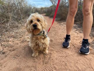
The Broome Visitor Centre have a Travelling with Dogs resource that you may find helpful.
Current weather forecast
Vehicles & Illegal Camping
Stay informed to avoid fines!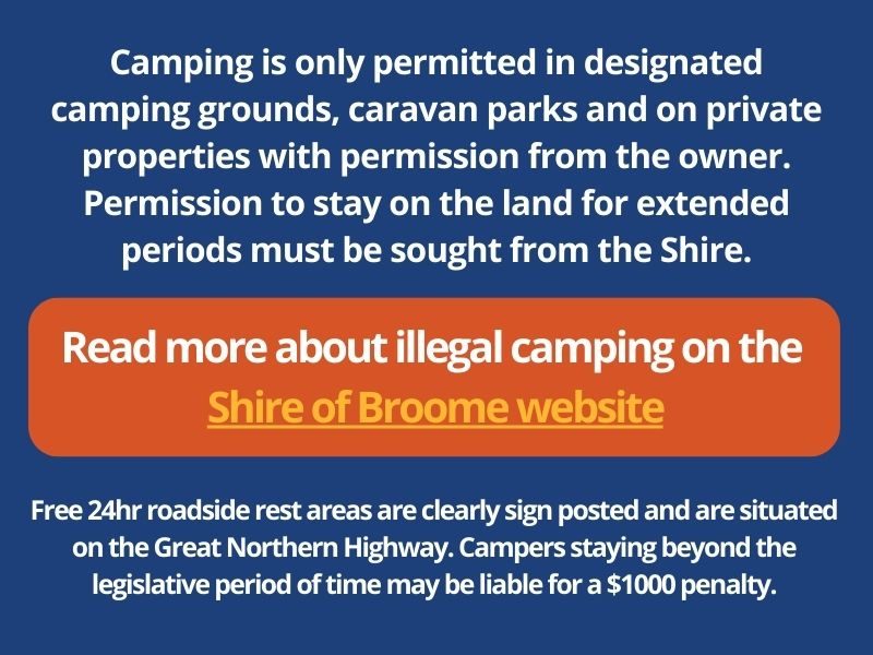
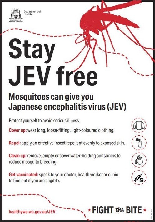
Japanese encephalitis virus
The Department of Health is urging residents and travellers in the Kimberley region to avoid mosquito bites following evidence of recent Japanese encephalitis virus (JEV) activity in the area.
Japanese encephalitis (JE) is a rare but serious disease of the brain that is caused by the Japanese encephalitis virus (JEV). JEV is spread by infected mosquitos to humans and other animals, such as waterbirds, pigs and horses. Waterbirds and pigs are important in the JEV transmission cycle as they can pass the virus back to biting mosquitoes. JEV cannot be directly transmitted (by direct contact) from person to person, animal to person, or by eating meat from an infected animal. Learn more here.
The Shire of Broome also has some valuable resources to stay safe in regards to mosquitoes here.
Residents of Broome are encouraged to ‘Fight the Bite’ as part of a ‘Healthy WA’ campaign to reduce the mosquito population and the incidence of mosquito-borne disease.
See more
Contact Us
PHONE: 08 9195 2200
EMAIL: [email protected]
ADDRESS: 1 Hamersley Street, Broome (First round-about as you enter town, next to Male Oval) VIEW MAP
POSTAL ADDRESS: PO Box 352 Broome WA 6725

Call 08 9195 2200